
finding neotropolis

A world beyond your imagination… (but not actually that far from civilization!)
South of Rosewood Blvd
East of California City Blvd West of Claymine Road
Edwards, CA
35.087439, -117.825400
35°05'14.8"N 117°49'31.4"W
(This is the same piece of property where Wasteland Weekend is held)
GoogleMaps and other navigation software tend to put our street address in the wrong location, which is why you should use the actual GPS coordinates when traveling to the event.
You can find the GPS location on GoogleMaps here, and Apple Maps here.
USE THE GPS COORDINATES.
NOT our STREET ADDRESS.
The street address of the event site, which you should NOT use for directions,
aka Wasteland Valley is:
17200 E Rosewood Blvd
Edwards CA 93523
Getting here:
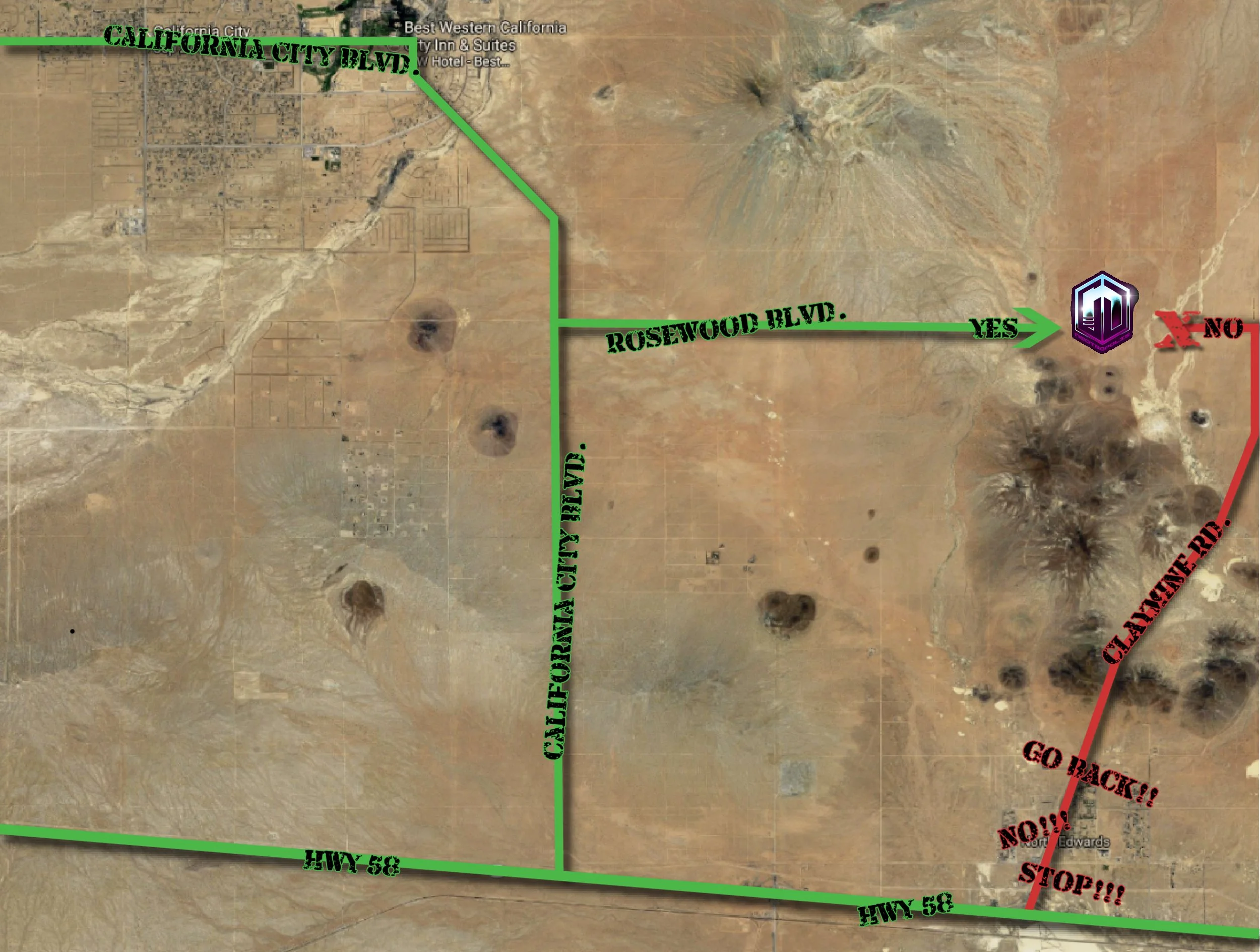
All attendees/performers/vendors/volunteers MUST enter Rosewood Blvd from the WEST, via California City Blvd, regardless of what directions your GPS may try to give you.
The GPS may try to take you down roads that are closed, impassable, or are not really “roads.”
DO NOT APPROACH FROM THE EAST SIDE OF ROSEWOOD or CLAYMINE.
If you try to come in from the east, you will not be able to enter the event from that direction.
Instead, you will be routed to the end of the line of cars coming from the WEST end of Rosewood Blvd. (We are keeping the east approach open as much as possible for emergency vehicles and staff members on official business). Trying to enter the event from the wrong direction will get you rerouted all the way around and to the back of the line to the west, so please don’t waste your time.
FOLLOW ANY/ALL ROAD SIGNS AND STAFF INSTRUCTIONS
We cannot overstate this one enough.
Our volunteer crew takes time to mark areas of concern with signs indicating rough roads, speed limits, sand hazards, and other important things. These signs are there to HELP YOU. If you ignore them, you may end up stuck in a spot you can’t get out of, or on a road you’re not supposed to be on. Please, please, follow any/all roadsigns and staff instructions.
Neotropolis opens to the public at 7am on Wednesday, April 29th.
For more information on our Entry Etiquette, please read this page.
After that, the gate is open 24 hours until the event ends.
When approaching correctly from the west, you WILL be able to bypass the line of cars IF everyone in your vehicle has already checked in and already have their wristbands. This only applies to Thurs, – Sat. only.
We have a special “return” lane for this once you get to the check-in area.
Return lane is NOT available on Wednesday, it is Thursday – Sunday only.
The road leading to the event (Rosewood Blvd.) is a dirt road, so please drive slowly and carefully.
The road is relatively flat with some usual dirt road bumps and dips. Rosewood is split into two sides, like a two lane street. Use the SOUTH lane on Rosewood, it is better for most non 4WD vehicles.
Almost any vehicle should be able to travel the road in without trouble, as long as you follow any/all signs and staff instructions.
Once you have arrived at Checkin, please follow any/all signs and instructions from staff.
Closest Airports:
Ontario (ONT), Burbank (BUR), and San Bernardino (SBD).
Los Angeles (LAX) is approximately 2.5 hours away from the site (not including traffic).
Directions:
From Los Angeles:
Take I-5 Freeway north. Merge onto CA-14 towards Palmdale.
About an hour later, you’ll take a be in Mojave, CA.
Turn right at the light onto CA-58 BUS E (signs for Las Vegas/Barstow)
About six minutes later (after you’ve passed the Mojave Space Port), you’ll make another right hand turn to merge onto CA-58.
Follow CA-58 eastward for about 20 miles (30 minutes).
Take the lefthand turn onto California City Blvd. and follow for about 6 miles (12 minutes) to Rosewood Blvd.
Turn right onto Rosewood Blvd.
Follow Rosewood Blvd (carefully) for about 6 miles (14 minutes), keeping to the posted speed limits and following any/all signs
You’ll arrive at our front gate (right hand side).
From San Diego:
Take I-15 Freeway north. Take I-215 towards Riverside. Merge back onto I-15.
Once over the mountains, look for exit 141. Merge onto US-395 North towards Bishop/Adelanto.
An hour later, you should come to CA-58 at Kramer Junction.
Turn left at CA-58 and head west for about 22 miles.
DO NOT TURN AT CLAYMINE ROAD, no matter what Google Maps tells you! IT LIES.
Continue on CA-58 up to California City Blvd.
Turn right onto California City Blvd. and follow for about 6 miles (12 minutes) to Rosewood Blvd.
Turn right onto Rosewood Blvd. It’s a dirt road, so please drive slowly and carefully and keep to the right lane.
Follow Rosewood Blvd (carefully) for about 6 miles (14 minutes), keeping to the posted speed limits and following any/all signs.
You’ll arrive at our front gate (right hand side).
From Central/Northern California:
Take CA-58 through Bakersfield and over the Tehachapi pass towards Mojave/Barstow.
Follow CA-58 eastward through Mojave. Keep going east for another 20 minutes or so.
Turn left onto California City Blvd. and follow for about 6 miles (12 minutes) to Rosewood Blvd.
Turn right onto Rosewood Blvd. It’s a dirt road, so please drive slowly and carefully and keep to the right lane.
Follow Rosewood Blvd (carefully) for about 6 miles (14 minutes), keeping to the posted speed limits and following any/all signs
You’ll arrive at our front gate (right hand side).
From Las Vegas:
Take I-15 South towards Los Angeles.
In Barstow, take exit 179 to merge onto CA-58 west towards Bakersfield.
Follow CA-58 west through Kramer Junction, and then for another 22 miles.
DO NOT TURN AT CLAYMINE ROAD, no matter what Google Maps tells you! IT LIES.
Continue on CA-58 west up to California City Blvd.
Turn right onto California City Blvd. and follow for about 6 miles (12 minutes) to Rosewood Blvd.
Turn right onto Rosewood Blvd. It’s a dirt road, so please drive slowly and carefully and keep to the right lane.
Follow Rosewood Blvd (carefully) for about 6 miles (14 minutes), keeping to the posted speed limits and following any/all signs
You’ll arrive at our front gate (right hand side).
The surrounding area looks filled with “roads,” but most are not finished, usable, or exist at all. Any roads other than the highways and major streets represented in Google Maps are purely dirt roads for city planning use only. Do not try to use them to get to the event, because you’ll either get lost, stuck, or sent to the back of the proper line anyway.
Some suggestions from long-time Wastelanders are to set your initial GPS/map guidance to a location in Mojave or California City, and then follow the above map/written instructions to get to site. Some examples are:
the Jack in the Box in Mojave located at 15536 CA-14, Mojave, CA 93501
the Best Western on California City Blvd. located at 10386 California City Blvd, California City, CA 93505
and/or Starbucks located at 9678 California City Blvd, California City, CA 93505
and then follow the directions to site from there.